
From the area you choose to a tracked action plan
Everything Territoire does today, with no promises about what does not exist yet.
Assessment
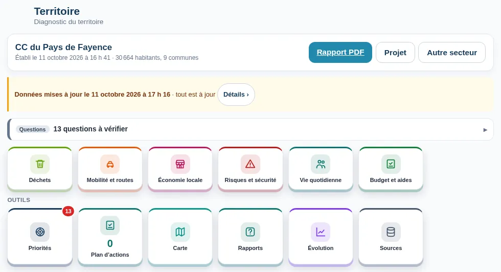
The assessment, step by step
You enter municipalities, a postcode, or the name or SIREN number of an inter-municipal body. An ambiguous name is offered as a choice, a typo as a suggestion. Territoire then reads public sources in about forty steps, showing progress: census, commuting and school trips, bus timetables, accidents, schools, hazards, roads, climate, facilities, municipal finances, property prices, waste. For the nine municipalities in the example, it took about a quarter of an hour.
The result is fixed and dated. It can be read again exactly as it was produced, and rerun in one click.
Analysis
Cross-checked analysis and a costed action plan
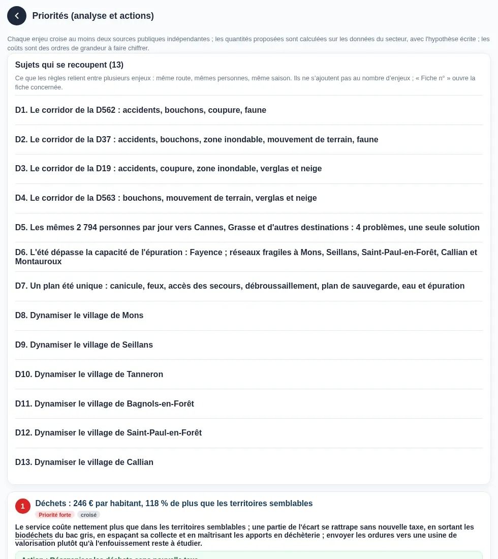
A finding states one fact. An issue combines at least two, from independent sources, and draws a conclusion. Each issue proposes a precise action: where, who leads it, by when, at what cost range, with which funding and which result indicator, followed by alternatives ranked from best value to heaviest.
The solutions you keep become an action plan: owner, budget, deadline, indicator and progress, action by action.
Map
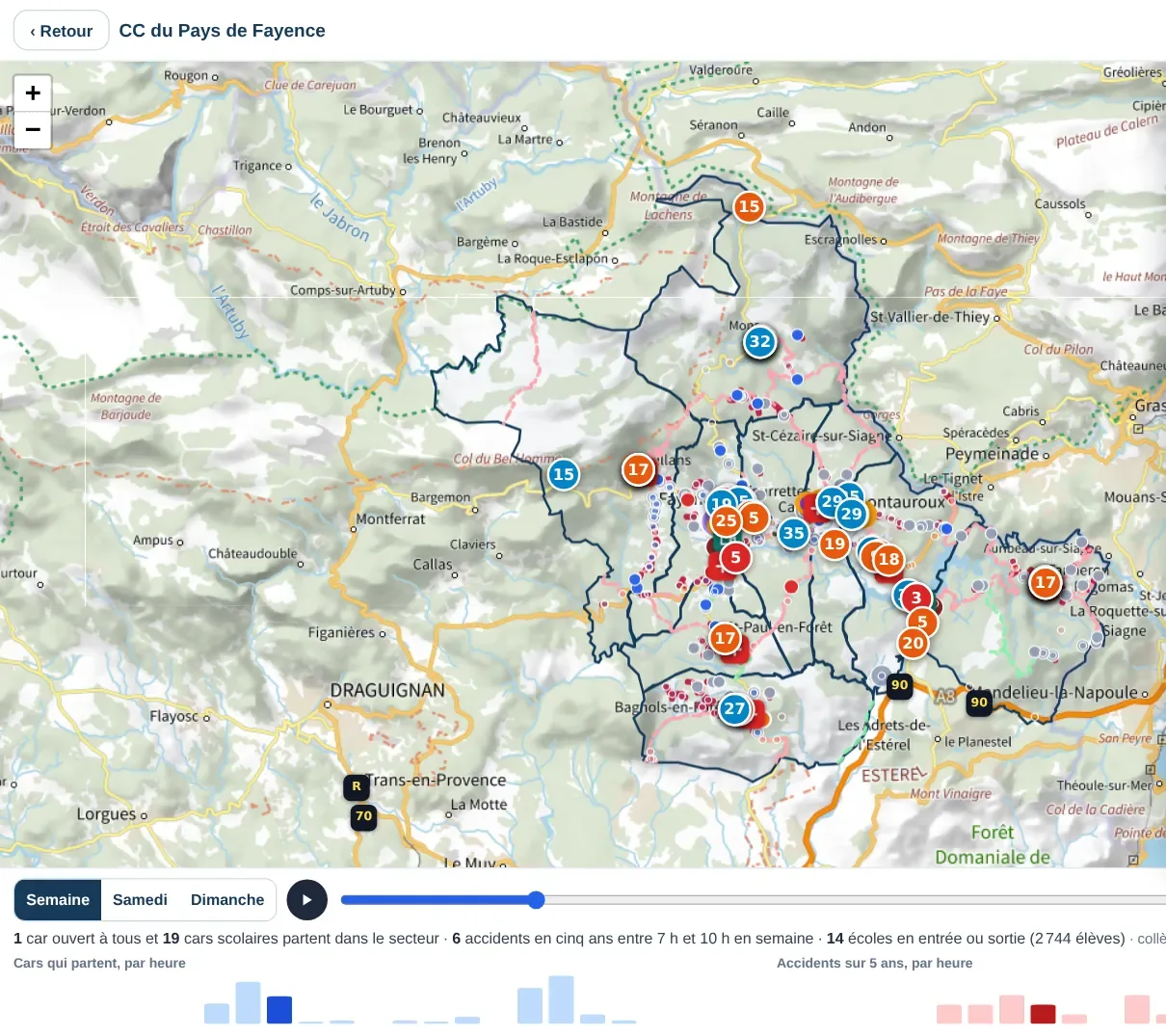
A map that changes over the day
Municipalities, bus stops, accidents, schools, commuting trips, estimated road load, narrow roads, emergency services, car parks, fixed speed cameras, hazard zones: each layer can be shown or hidden, and each item opens its details when tapped.
Choose weekday, Saturday or Sunday and slide the time from 5 am to 11 pm: bus departures, accidents in that time slot and schools at opening or closing time appear.
Scenarios
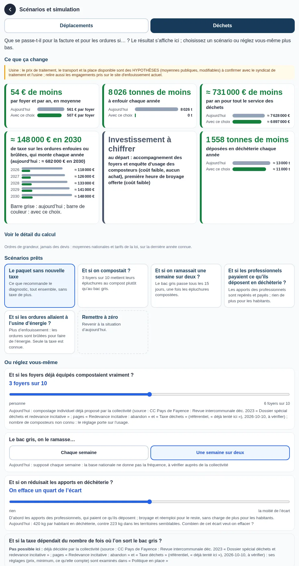
Simulate before you decide, in plain words
Two simulators, travel and waste, ask simple questions (“What if we composted?”, “What if one driver in ten shared their car?”) and answer with large “before / after” cards. Travel: car sharing, home working, express buses, staggered hours, authorised housing, bottleneck by bottleneck. Waste: composting, residual bin every other week, trade waste at recycling centres, incentive element, energy-recovery plant or landfill; results in tonnes, service cost, landfill tax from 2026 to 2030 and euros per household (an average). Nothing in the assessment is changed.
Files
Files that group what belongs together
Several issues often concern the same road: accidents, bottlenecks, a flood zone, a possible closure. Territoire groups them into one file per road, with a single contact, the road authority, and steps in order: measure, then quick and cheap, then heavy works.
It also spots issues that affect the same people, on the same commuting trips: one action can then address several. Each file points to the issue sheets it groups.
Updates
Your searches are kept and updated
Every area studied is kept. When you open it, Territoire shows, source by source, what is up to date and what has probably been published more recently. “Update” reruns only those steps and the ones that depend on them, keeps the others, and says what changed. Apart from the monthly monitoring, nothing reruns without you.
Road safety
Accidents: when minor accidents are missing
If an area has a much higher share of serious or fatal accidents than its department, minor accidents are often not all recorded by the police there. Territoire computes this from the same national files, prints its rule and states it in the report, with an estimate of the missing accidents.
Monitoring
Monthly monitoring and your own alerts
Each monitored area is updated every 30 days. If an alert appears or gets worse, or if new funding applies to an action in your plan, you receive an email. The “Évolution” screen also shows what has improved.
Your teams can also keep a register of alert points (fly-tipping, obstructive parking, damage, unauthorised occupation…). It records facts and places, never people, and nothing is deleted in one click.
Waste
Waste: the best organisation at the lowest cost
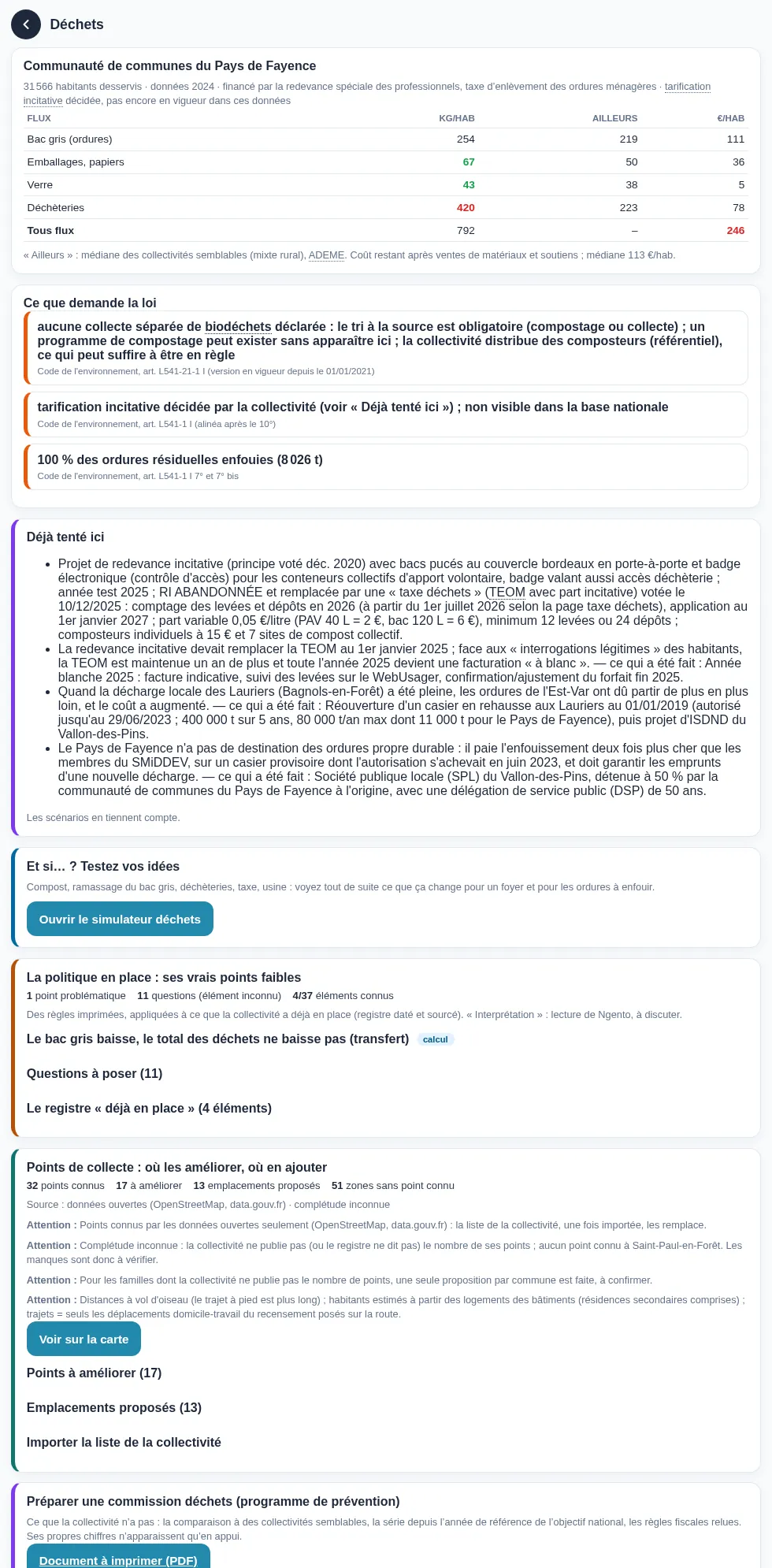
Cost per resident compared with similar authorities, legal compliance, and costed scenarios to reduce the bill without creating a tax. Territoire also prepares a waste committee meeting: comparison with similar areas, shifts between waste streams, taxes and questions to ask. More on waste.
Water
Water: summer, leaks, sanitation
Drought restrictions, dry rivers, groundwater, flows, abstractions, climate projections, network efficiency and individual sanitation: Territoire draws three conclusions (will water last the summer? what do leaks cost? where does individual sanitation stand?), each with its action, and also says what is going well. More on water.
Multi-year tracking
Contracts and programmes
A water and climate contract, a waste prevention programme, a climate plan or a mobility plan is tracked in the same place as the assessment: plan actions, indicators calculated from public data, grant schedule, email alerts before a deadline, annual review as a PDF. More on contract tracking.
Mobility
The simplified mobility plan
In the Mobility and roads theme: a residents' survey, with no account and no address; car-pooling actually done, read from the national proof register; before / after evaluation of your trials; and a draft plan as a PDF. More on the simplified mobility plan.
Road closures
Road closures and contingency plans
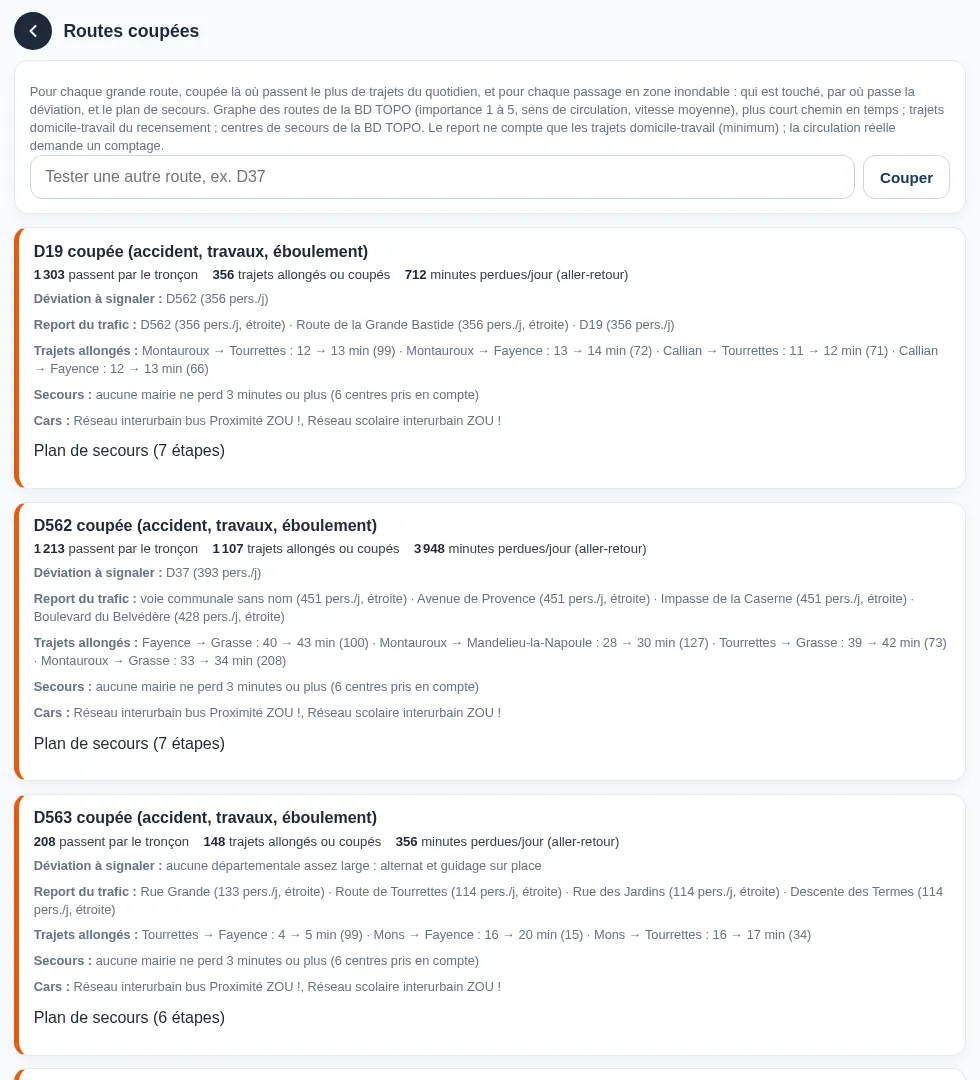
For each main road, and each crossing of a flood zone: who is affected, where the diversion goes, and the contingency plan. You can also test any road. More on road closures.
Report
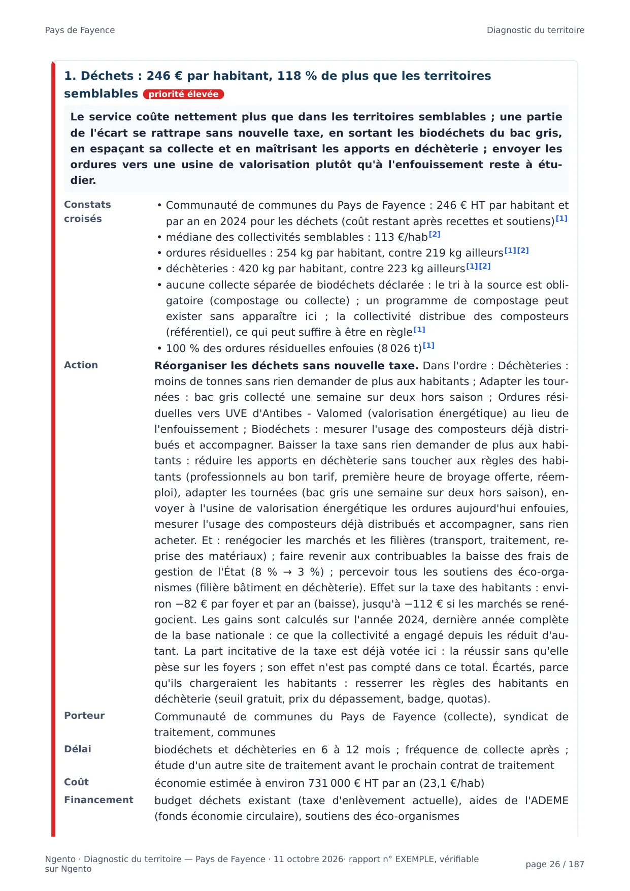
A PDF report, complete or by topic
The report includes the summary for decision-makers, the action plan, issue sheets, the map of black spots, appendices by municipality, what the report does not know, and numbered sources. It can be complete or limited to the topics you choose.
Topics
Questions and reports, by audience
Thirteen topics group the questions a municipality, an inter-municipal body, an institution or a private organisation asks: mobility and access to services; road safety; street lighting at night; natural hazards, climate and winter; water, sanitation and networks; housing and planning; public safety and alert points; local taxation; waste; preparing a waste committee meeting; shops, services and village vitality; emergency planning and wildfires; economy and jobs. For each, the screen shows the issues in the area that answer it, and the report can be limited to it.
Projects
Linked to your projects
An assessment can be linked to a project in Ngento's Projects module. The project file then includes, in its “The area” section, the key figures and the six priority issues, recalculated each time it is opened.
Demo
Try the demo
An online demo opens an example assessment, its map, its simulators, an example project and example events. It is reserved for French public bodies: municipalities, inter-municipal bodies, departments, regions, syndicates, public establishments and State services.
Enter your work email address: it is checked against the official directory of the French administration, then you receive a code by email. Access lasts one month. The demo is read-only: nothing you do in it is saved. The tool is in French.